tt
tt
tt
tt
tt
tt

Technology
•
The World According to Umbra
On the California Coast, Umbra is building orbital radars to see the Earth more clearly than ever.

Get the Mag in Print.
Arena publishes four stunning print editions per year, full of stories just like this one on American technology, capital, and industry.


A Very Santa Barbara Story
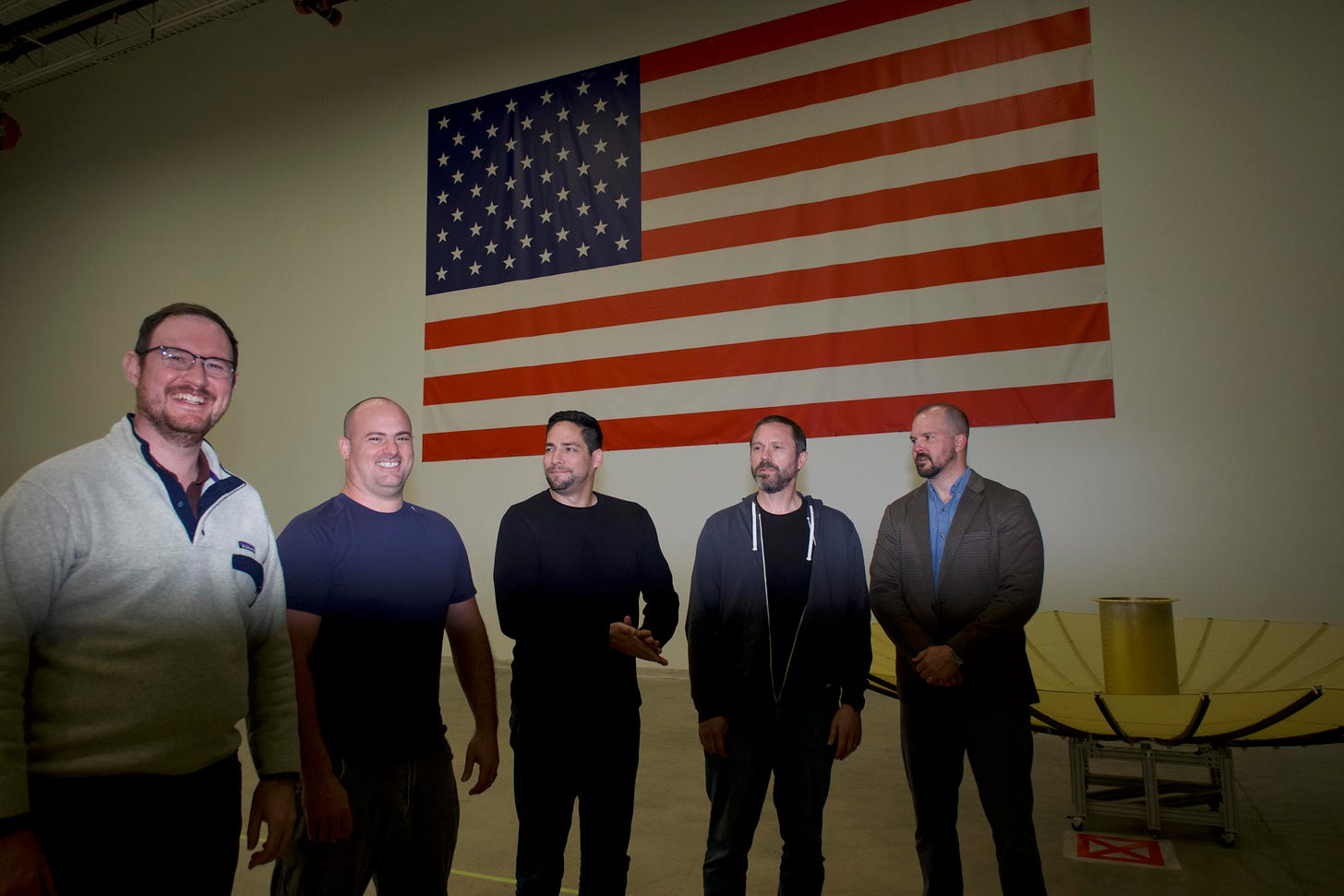
On a beautiful street in downtown Santa Barbara (they all are, really) is a five-story building with a classic Spanish-Californian facade, complete with cornices and vintage ironwork over the perfectly-spaced windows. If a pedestrian were to guess just what kind of business occupies it, I think they’d guess wrong. A boutique law firm, perhaps. Maybe a high-end architecture practice? An art gallery? The answer is that some of the world’s most advanced imaging satellites have been designed and built there by a company called Umbra. On January 11th, Umbra launched its twelfth synthetic-aperture radar satellite (SAR is an advanced radar system for creating high-resolution imagery — more on this later) on a SpaceX Falcon rocket carrying 39 other small satellites. The company, founded in 2015, launched its first three satellites over a one-year period beginning in 2021. Now, it is preparing to open a new manufacturing facility in nearby Goleta, with the capacity to produce more than 50 satellites per year.
Even with a small constellation — for now — Umbra has made big news with its capabilities.
When Wagner Group boss Yevgeny Prigozhin’s plane went down in August 2023 after his short-lived mutiny against Vladimir Putin, Umbra’s SAR imagery was the first to show the crash site; those images, taken by radar at night when cameras couldn’t see, ran on CNN and showed the state of the wreckage. For a company whose first satellites had been up for only two years, it was a significant moment. Hardware that had been designed and built by a very small team on the quiet California coast was the source of a major international headline in a bloody conflict a world away — and the images were on TV!
David Langan is Umbra’s CEO and a lifelong resident of Santa Barbara. He began his aerospace career in a way I can only describe as characteristic of the town. “I had just come back to Santa Barbara from studying mechanical engineering at UC Irvine and was starting to look for a job in the field. I ran into a woman while I was walking my mom’s dog one day,” he said. “She recognized the dog, but she didn’t know me. I started talking to her, and she found out I was looking for a job. She introduced me to a contact of hers, and two days later, I had a job at Orbital ATK, which is now part of Northrop Grumman. And that was my career for the first seven years.”
I repeated the facts back to him, asking with some amusement, “a woman recognizes your mom’s dog, and then you’re conscripted by Northrop Grumman? It’s very Santa Barbara.” (The California coast, idyllic as it is, has long been a center of American military technology)
“That’s exactly how it went. Conscripted is a good word,” he said back.
Years later, after time in the defense world and a growing conviction that radar remote sensing could be done better, faster, cheaper, more openly — he left to start Umbra. Today, Umbra operates one of the most sophisticated synthetic-aperture radar (SAR) constellations in the world, public or private. It is an undeniably exciting frontier in the long technological story that is radar.

What is Radar, and Why is My Aperture Synthetic?
Radar is a simple but brilliant technology. James Clerk Maxwell’s theoretical predictions in the 1860s that electric and magnetic fields could propagate through space established that “waves” could exist before anyone had produced or detected them. Years later, experiments by German physicist Heinrich Hertz showed that radio waves behaved exactly as Maxwell had predicted: they reflected, refracted, diffracted, and polarized like light visible to our eyes.
If invisible electromagnetic waves behave like visible light, and like sound, then in principle it should be possible to calculate the distance between objects by creating a wave, waiting for it to be reflected off some object or surface, then timing how long it takes for the wave to return. It is not unlike shouting in a cave and waiting for an echo to gauge how deep the cave is, though light travels much faster than sound.
A simple radar system uses a transmitter to generate radio frequency signals, and an antenna to radiate them as a wave. The antenna can also “catch” the returning signals, which are then processed. By measuring the time it takes for a signal to return, you can measure the distance. This system, with a stationary antenna, is the most primitive one-dimensional radar.
If you allow the antenna to move along another axis (or rotate), you have created a two-dimensional radar. Maritime radars detect other vessels by spinning 360 degrees and looking for them; their range is determined by the curvature of the Earth and the height of the radar above the water, not unlike your own line of sight from a beach watching ships slip over the horizon. If you were twice as tall as you are, you’d be able to see farther.
Radar came of age right as the world was about to be plunged into the chaos of the Second World War. It was in 1940 that the United States Navy officially adopted the acronym of ‘radar’ (radio detection and ranging) and implemented the first maritime radars aboard US ships.
If you add another dimension by allowing a radar to look up (either literally by moving the antenna up and down, or by creating a phased array of multiple antennas), things start to get interesting. Now, you can start to resolve flying objects and get information about their position, altitude, direction, and speed. Given the propensity for metal objects in the sky to cause trouble — I’m thinking of aircraft (both friendly and unfriendly) and missiles (all unfriendly) — you can imagine just how useful this third dimension is.
The United Kingdom’s “Chain Home,” with antennas dotting the southern English coast, had ranges just far enough to see groups of German aircraft across the English Channel in France. Those basic radars gave the men of the Royal Air Force a fighting chance against the much larger Luftwaffe, allowing them to concentrate their responses to German air raids in their heroic defense of Britain in the summer and autumn of 1940.
It was also in 1940, during the Battle of Britain, that the British first put radars onboard planes themselves. Airborne radar is enormously useful because it can tell you what’s on the ground, especially at night. The catch is that the resolution of an image depends on antenna size. By concentrating power effectively, a large antenna produces a sharper image, the same way a larger telescope mirror gathers more light and reveals finer detail. The stationary, ground-based antennas of Chain Home were enormous steel towers — even the largest American bombers of the age couldn’t fit anything close to their antennas on board.
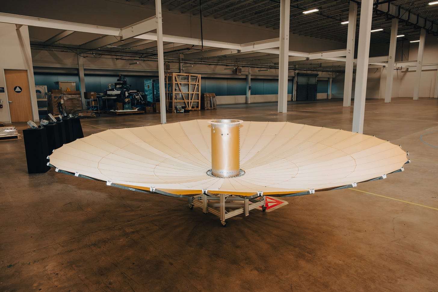
But with a bit of clever engineering, you can fake it. A radar mounted on a moving platform — an airplane, or eventually a satellite — can take measurements at many points along its flight path and then combine them mathematically, as if all those individual measurements came from one very long, impossibly long, antenna. The “synthetic aperture” is the imaginary antenna you’ve constructed via computation. So, an aircraft flying along a path a mile long can “synthesize” an antenna a mile long, achieving resolution that would otherwise require an absurdly large physical structure.
Early SAR systems filled aircraft with racks of specialized processors; the images they produced sometimes took longer to compute than the flight itself. As is the story with so many technologies whose infancies were in the first half of the twentieth century, the transistor and chip revolution of the second half of the century changed everything. The explosion of computational power, tracked by Moore’s Law, made it possible to measure more with less, and measure it at greater and greater resolutions.
The first SAR satellite for Earth observation was called SEASAT. Launched in 1978, NASA used SAR from 500 miles up to measure Earth’s oceans in unprecedented detail — seeing wave patterns, surface winds, sea ice, and ocean topography through clouds and darkness. SEASAT operated for just over 100 days before a short circuit killed it, but in that time it proved that spaceborne SAR could work really well.
Today, several commercial entities operate space-based radar. Among them, Umbra has the distinction of having produced the world’s highest-resolution commercial SAR image. The image shows the historic Dole pineapple plantation outside Honolulu, resolved at just 16 centimeters. To give you a sense of just how impressive 16-centimeter resolution is from space: at that resolution, a satellite orbiting the Earth multiple times per day can reliably count pineapple plants. Individual pineapples are dodgier but possible. You might be able to see an enormous grapefruit, but lemons are out of the question.
I don’t need to tell you that Umbra’s customers aren’t paying them to count fruit. The implications of worldwide, high-resolution SAR imagery, available 24/7 are enormous — for militaries, intelligence agencies, corporations, investors, scientists, and plenty of other people who want to observe the Earth and the drama happening on it with precision never before available.
How to Build a Radar Satellite from Scratch
Before Umbra raised a dollar or hired any employees, David Langan was cutting paper models on a kitchen table. “I was just thinking, how could these things fold together, and trying to visualize the fully 3D structure with the mechanism and mesh and cables and all the things that might be necessary,” he said. Langan and his co-founder Gabe Dominocielo bootstrapped the company for three years, buying oscilloscopes and spectrum analyzers off eBay from the 1980s. “They still worked,” Langan said. “They actually worked really well, so we still rock them.”
From the electrical lab in the Santa Barbara building, with the old hardware still on the shelves, we walked to Umbra’s clean room, converted from what used to be several classrooms, once painted in garish greens and purples — that Umbra gutted and rebuilt. “All of our satellites to date have been built and integrated in this room,” Langan said, speaking with me inside that clean room. Down the hall are the rooms where the original testing took place; they are now conference rooms. There’s a storage room stacked from floor to ceiling with Uline bins full of tiny components — enough to build six satellites. In the new Goleta facility, parts will ride on carousel-like contraptions that rotate up into the air, a Ferris wheel for satellite components.
Part of Langan’s previous job at Northrop Grumman had been pricing out satellite components, so he had “a somewhat encyclopedic knowledge” of what things cost. Batteries were hundreds of thousands of dollars. Custom solar arrays built by a contractor would run into the millions. “You could just say, ‘no, we have to build that ourselves because there’s no way we could afford to buy a solar array,’” he said. “And even if we could, we didn’t want to wait.”
Umbra’s co-founder Gabe Dominocielo said this: “I knew David could make it work technically. My focus was whether it worked economically. If it didn’t make sense at the unit level, none of it mattered. From day one, we were obsessed with cost and efficiency.”
Today, just about everything at Umbra is vertically integrated, with the exception of the rocket (thank you, SpaceX) and the ground stations near the North and South Poles that help the Umbra constellation work — though, on the latter front, Umbra may very well change things.
“We looked at design papers and scoured the internet and textbooks,” Langan remembered. “We applied that approach to absolutely everything. How do you build a battery? How do you build a solar array? We broke it down to how we could build it in the most efficient manner possible, with the most modern parts possible. And we built the entirety of the spacecraft and the payload with that methodology.”
They patented their antenna design and raised their first seed funding in early 2018, during the California wildfires. “There was lots of ash in the air. People were coming into the office with masks,” Langan recalled.
When Umbra needed to test whether their first radar could actually generate an image, they found a pilot willing to let them strap the instrument — about the size of a fire hydrant — to the side of a skydiving plane. Young Umbra engineers wore parachutes and fired the radar out the open door over Goleta. “This is the very first shot that we captured,” Langan said, pointing to a photo taped to a whiteboard. Then Gabe Dominocielo sent them back up — this time with Red Bull cans scattered in a field below. “We told people that we were going to be able to see a Coke can in the field,” Langan explained. “And we caught those in a later shot.”
Mike Francis was the third employee. He’d grown up in Connecticut, gone to MIT, and spent ten years at Northrop Grumman in El Segundo. “My wife and I were looking to get out of LA,” he told me. “We wanted something a little more family oriented, a bit of a small town. I was looking at Santa Barbara, saw this posting, and I literally just applied online. David gave me a call.” That call lasted for three hours; today, Francis is in charge of building Umbra’s current satellites, and leads the team designing the next ones.
When Langan and Dominocielo started the company, they had to take it on faith that launch costs would come down — Langan called it “pressing the ‘I believe!’ button.” In early 2021, SpaceX introduced “Rideshare” — where dozens of satellites can be launched on a single Falcon rocket (renting the whole rocket would cost a single customer around $60 million, impractical for smaller satellite companies). “That ended up being a huge catalyzing event for the American space industry,” Langan said. For Umbra, it was critical.
Rideshare works because SpaceX standardized the interface. Umbra’s satellites — and their rideshare buddies from other companies — bolt to a fifteen-inch ring on a shared plate aboard the Falcon 9. The interface is not unlike the stem of a Brussels sprout plant, with satellites neatly spaced along the “stalk.” Once the Falcon has slipped into space, the shell of the spacecraft opens, and one by one the satellites detach. SpaceX provides the ring specification — the circular bit that the satellite gets bolted onto — and the ride to space; the customer provides everything else, including the separation system. Mike Francis told me a bit more about that process: “They have a whole test suite you have to go through,” he explained. “You have to prove to them it’s actually going to deploy so that you don’t get stuck on there.”
About three and a half months before launch, Umbra delivers an environmental test report: proof that the satellite has survived stress testing like a shaker table; that all its deployments will work; and that it won’t damage anything else on the rocket. A month or so out, the Umbra team brings the satellite to the integration facility, either at Cape Canaveral or Vandenberg, just up the coast from Santa Barbara, and bolts it onto the plate. After launch, depending on the mission profile, it can be anywhere from an hour to several hours before the satellite is released. First contact with Umbra’s ground stations typically comes within thirty minutes of separation. The solar arrays deploy immediately; the antenna deployment is commanded from the ground once the team confirms everything else is operating normally. Forty-seven hours after one recent launch, Umbra had its first image.
✺
COO Todd Master took a longer path to Umbra. A former Air Force officer, he’d spent five years at DARPA before joining the company. But his connection to Langan went back years earlier, to a classified review room at a big prime contractor when they were both working for different parts of ATK. A young engineer was presenting an electromechanical payload. “Everybody’s just blown away,” Master recalled. That young engineer was David Langan. They worked on projects together. Only during his Umbra interview, years later, did Master learn it hadn’t just been Langan’s first presentation. “It was his first project!” Master said, laughing.
“We actually talked about Todd for a couple of years before we hired him,” Langan told me. “We had a plan for Todd.”
As Master and I drove from downtown Santa Barbara to the company’s new manufacturing site in Goleta, the quaint streets gave way to larger boulevards, office parks, and industrial space — though the beautiful oaks largely remain. I saw two men walking on the sidewalk in Lockheed Martin polo shirts.
“This is really the transition you’re seeing at Umbra,” Master said, “from the funky, cool, scrappy startup to what a serious aerospace and defense company is.” Today, Master is leading a major expansion as GM of Space Systems — selling not imagery but the actual satellite components Umbra has developed to the broader industry.
We talked a bit about the talent at Umbra. He came up through the traditional aerospace world — Air Force, defense primes, DARPA — but the talent pipeline feeding Umbra looks almost nothing like the one that trained him. “A lot of people are familiar now with CubeSats,” he explained. “It was invented at Cal Poly. So we’ll have students graduating from college, fresh out of undergrad, who come to us and interview who’ve actually operated satellites for years.”
The CubeSat framework was developed in 1999 by two professors, one at Stanford and one at California Polytechnic University, San Luis Obispo. CubeSats have a standard measurement of 10x10x10 centimeters and a mass of two kilograms or less. The standardized format made it possible for truly small customers like colleges and early-stage startups to launch real satellites. Several thousand CubeSats have been launched, mostly as academic projects. For Umbra, recruiting from Cal Poly and similar programs meant being able to hire young engineers with actual hands-on experience designing satellites and coordinating missions.
“We found this kind of special place,” Master said as we pulled into the parking lot. “It’s an office park, but office park has a negative connotation to me. This is one of the nicest I can imagine. It’s peaceful and serene. When David first saw it, he was like, ‘It’s so serene, the birds outside.’ He liked it.”
Sitting in Langan’s office, with a view of some winding California oaks over the parking lot, I asked the man in charge what technical achievement he was most proud of as CEO. “There are so, so many,” he began. “We built an exceptional radar payload, soup to nuts, from bolts and microwave integrated circuits, with engineers right out of undergraduate study. And we did it in just a couple of years, and it let us come from behind and dominate with far fewer satellites. It set us up for a path where we know we’re just getting started. It is going to get so much better. And the competition we’re up against is not going to grow in the way that we can and will grow in the next couple of years.”
The initial manufacturing goal of the Goleta facility is to scale to a point where the team builds one satellite per week. I was curious whether Todd and David thought there was a saturation point — whether at some point there would be enough satellites to meet all the demand for this kind of imagery. “I think there is,” Master said. “And that really gets down to what the quantity gets you. We’re not just building to serve quantity, because quantity is only part of scale. All that’s really giving you is shorter gap times between collections. But that doesn’t necessarily mean more capacity per system, which is a big metric that we use. We have a very high-capacity system.”
“I think it’ll be hundreds to thousands,” Langan said. “I don’t think SAR satellites will be numbered in the tens of thousands. That won’t happen. Yet I’ve been surprised at the massive expansion of radar satellite procurement, and we’re focused on building new capabilities that integrate persistent collection with a persistent connection — an always-on, resilient architecture.”
✺
For a company that does critical business with US military and intelligence (and numerous US allies), it may surprise you that the Umbra website has a public price list, and a dashboard for anyone to purchase new or existing imagery, as well as a considerable library of open data. A one-meter resolution SAR snapshot of a five-by-five kilometer area can be yours for just $675. A finer resolution will cost you — $3,250 for 25-centimeter resolution on that same area.
Critically, Umbra issues its paid imagery under a Creative Commons license — specifically the CC-BY-4.0 license, which is an open-source license requiring only attribution by the licensee. I was somewhat surprised to learn that it was at one time standard practice in the remote sensing industry for companies to sell images under highly-restrictive licenses, enjoining purchasers from doing much with the images they’d bought.
Joe Morrison, who leads Umbra’s remote sensing business, explained the problem this way: “The reason why the CC-BY-4.0 license is so important is this: how do you build an industry on top of this new source of data if you’re not allowed to share the results with anyone else?” He came to Umbra as a convert. At his previous firm, he’d been purchasing satellite imagery for both defense and commercial use cases, developing AI to extract information from it. “I spent half my time on the phone with salespeople who would refuse to answer my questions,” he told me. “I’d say, ‘I have $100,000, what can I buy? I’m waving money at you. What does it cost?’” The opacity drove him so crazy that in 2020 he wrote what he called “a farewell letter to the industry” cataloging everything that was broken about satellite imaging.
That’s how Umbra found him. “They called me and said, ‘we’re going to change all that.’ And I was like, ‘I don’t believe you. The licensing, the pricing, the API — I don’t believe you.’ And they said, ‘well, if you don’t believe us, why don’t you come help us fix it?’”
“There were some wild licensing schemes” for satellite imagery, Langan told me in his office at the new manufacturing facility in Goleta. “There would be rules like only one person can look at it, and you can’t extract any information from it. And if you do, you need another license for that. It made it very difficult for folks in the scientific community and commercial businesses to use remote sensing data to solve their problems.”
Morrison talks about a “peace dividend,” i.e. the benefits that the public will enjoy from the military-driven investments in SAR. “You design a constellation to be able to do that incredibly demanding thing,” he said — things like persistent surveillance, custody of high-value targets, and battlefield awareness. “And now you have all this capacity to do other things, like monitor bridges. In the future, there will come a time when no one is ever lost at sea, because if you want to, you can make sure that you can find that vessel from wherever you last saw it.”
“My mental model for that is GPS,” Morrison said. “We created GPS for a defense purpose, and now people use it to chase Pokémon.” For SAR, discovering the “Pokémon” type applications is only possible if the data aren’t just available for purchase but for use.
One of Langan’s favorite unexpected customers in this camp was a marine biologist who used Umbra’s SAR capabilities to monitor penguins in Antarctica. For obvious reasons, it is impractical to sit and watch penguins in situ for long stretches of time, particularly during the winter. Camera satellites can’t monitor penguins as reliably because of clouds. But with high enough resolution, a space-based SAR system can count penguins, track their movements for long periods of time, in the dead of winter, no matter the weather. “I thought that was so cool,” he said.
✺
Jason Mallare leads Mission Solutions — the part of Umbra’s business built for highly customized missions for sovereign military and intelligence customers. He previously worked with Langan at Orbital ATK.
“Most conflicts involve non-human objects being moved strategically, as clandestinely as possible,” Mallare told me. “But they’re trucks, tanks, and boats. And so we focus on metal on the ground and metal on the ocean. It shows up really well in SAR. SAR is all-weather, day and night. You can’t hide under clouds. You can’t hide at night. You can’t hide under a tarp. We penetrate the tarp.”
He described a use case one unnamed partner had shared: that partner was trying to assess whether a particular plot of land might be used for a mobile missile launcher. They were doing full-spectrum monitoring — tracking phones of people potentially scouting the site. “Without SAR, you’d be able to hide,” Mallare explained. “You’d be able to work at night. You’d be able to work when it’s cloudy. And with only a few space systems, if it was not proliferated and not persistent, you could just wait — it goes overhead, okay, everybody come on out, get to work.” Persistent SAR changes the calculus. “Now you hold it in custody and say, okay, we’re pretty sure you’re doing something there, and you’re not going to be able to do it in the shadows. We’re just going to monitor that site constantly, and we’re going to know exactly what you’re doing.”
“Having genuine transparency about where major movements are happening is a good thing for the people and countries that believe in sovereign borders,” Mallare explained. “And it’s a really bad thing for the people and countries that don’t.”
These two sides of Umbra’s business — commercial remote sensing and national security work — turn out to reinforce each other. On the commercial side, the attraction is price and ease of access, even for small-time customers; for government customers where failure isn’t an option, reliability is invaluable. Morrison explained the logic: “A big part of the pricing strategy is to catalyze a new industry, catalyze an entirely new category. At the opposite end, when we put together custom missions for our defense and government customers, that pricing is based on their budget, the value they’re trying to attain. Ultimately, they’re all trying to attain deterrence. Deterrence is driven by persistence. Your adversary needs to know you’re watching all the time. You don’t commit crime under a streetlight.”

New Space
Umbra is cognizant of itself as a “New Space” firm — in which its engineers try to build from first principles, and its strategy is based on radical cost reduction to get new opportunities.
“It’s a common human trope to see something remarkable and then want to template it,” Mallare said. “I think that’s been the plight of the aerospace industry. We started doing something that’s remarkably hard. We went to the Moon, we put a man in space, we put a satellite in space. And we realized it was hard, and had some failures along the way. And we told ourselves, let’s never make that one failure ever again. Let’s document it. Let’s template it. Let’s put a process around it. And we do the same for the next failure. Eventually, you go for decades and you end up with this library of thou shalt not’s.”
“New Space” means throwing out the books, Mallare said. “We’re not going to listen to thou shalt nots.’ We’re not going to start there. We’re going to start from what makes sense. Yeah, what do we need? What do we need? What can we do? What can we figure out? David led the early team that built most of our foundational technology. The transceiver, the amplifier, all the antennas. He’s like, I’m just going to do it. I’m going to launch it. I’m going to figure it out. And then I’m going to iterate.”
Langan, for his part, thought from the beginning that Umbra’s biggest weapon would be the combination of building its own hardware at a much lower cost than larger firms — in the cleanroom that was once a purple classroom, mind you. “In the early days, we were coming from behind,” he told me. “We were one of the last companies competing in the radar remote sensing market to come to market. We did it with less, we did it with fewer satellites. And we knew we had great conviction — we knew we were going to bring a much more capable system that was going to dramatically reduce cost. So, we knew we could use pricing as a weapon early on to force our way in and gain market share. My costs are so much more manageable than my competitors.’”
When a market doesn’t exist, the price of the thing you want is effectively infinite. Before SpaceX made cheap launch possible via Rideshare, itself made possible through reusable rockets, startups simply couldn’t afford to launch small satellites — not at any price that made business sense. Before Apple made the iPhone, a smartphone with the power of a computer wasn’t “expensive”; it just didn’t exist. The same was true of personal computers before they became personal, of countless technologies that went from unimaginable to ubiquitous once someone figured out how to make them cheap enough. Umbra is trying to be one of those companies, making knowledge of the Earth’s surface and the things happening on it…. ubiquitous. And synthetic aperture radar, invented by American engineers, refined over decades of classified aerospace work, is now being offered to the world at prices that would have seemed absurd a generation ago.
Today, Umbra is 11 years old and growing faster than ever. What will the next decade and beyond look like as its constellation and capabilities grow? What would you do if you could see the whole Earth, not just in one pretty photograph, but down to the level of objects.
Technology
•
The World According to Umbra
On the California Coast, Umbra is building orbital radars to see the Earth more clearly than ever.
Get the Mag in Print.
Arena publishes four stunning print editions per year, full of stories just like this one on American technology, capital, and industry.
A Very Santa Barbara Story
On a beautiful street in downtown Santa Barbara (they all are, really) is a five-story building with a classic Spanish-Californian facade, complete with cornices and vintage ironwork over the perfectly-spaced windows. If a pedestrian were to guess just what kind of business occupies it, I think they’d guess wrong. A boutique law firm, perhaps. Maybe a high-end architecture practice? An art gallery? The answer is that some of the world’s most advanced imaging satellites have been designed and built there by a company called Umbra. On January 11th, Umbra launched its twelfth synthetic-aperture radar satellite (SAR is an advanced radar system for creating high-resolution imagery — more on this later) on a SpaceX Falcon rocket carrying 39 other small satellites. The company, founded in 2015, launched its first three satellites over a one-year period beginning in 2021. Now, it is preparing to open a new manufacturing facility in nearby Goleta, with the capacity to produce more than 50 satellites per year.
Even with a small constellation — for now — Umbra has made big news with its capabilities.
When Wagner Group boss Yevgeny Prigozhin’s plane went down in August 2023 after his short-lived mutiny against Vladimir Putin, Umbra’s SAR imagery was the first to show the crash site; those images, taken by radar at night when cameras couldn’t see, ran on CNN and showed the state of the wreckage. For a company whose first satellites had been up for only two years, it was a significant moment. Hardware that had been designed and built by a very small team on the quiet California coast was the source of a major international headline in a bloody conflict a world away — and the images were on TV!
David Langan is Umbra’s CEO and a lifelong resident of Santa Barbara. He began his aerospace career in a way I can only describe as characteristic of the town. “I had just come back to Santa Barbara from studying mechanical engineering at UC Irvine and was starting to look for a job in the field. I ran into a woman while I was walking my mom’s dog one day,” he said. “She recognized the dog, but she didn’t know me. I started talking to her, and she found out I was looking for a job. She introduced me to a contact of hers, and two days later, I had a job at Orbital ATK, which is now part of Northrop Grumman. And that was my career for the first seven years.”
I repeated the facts back to him, asking with some amusement, “a woman recognizes your mom’s dog, and then you’re conscripted by Northrop Grumman? It’s very Santa Barbara.” (The California coast, idyllic as it is, has long been a center of American military technology)
“That’s exactly how it went. Conscripted is a good word,” he said back.
Years later, after time in the defense world and a growing conviction that radar remote sensing could be done better, faster, cheaper, more openly — he left to start Umbra. Today, Umbra operates one of the most sophisticated synthetic-aperture radar (SAR) constellations in the world, public or private. It is an undeniably exciting frontier in the long technological story that is radar.
What is Radar, and Why is My Aperture Synthetic?
Radar is a simple but brilliant technology. James Clerk Maxwell’s theoretical predictions in the 1860s that electric and magnetic fields could propagate through space established that “waves” could exist before anyone had produced or detected them. Years later, experiments by German physicist Heinrich Hertz showed that radio waves behaved exactly as Maxwell had predicted: they reflected, refracted, diffracted, and polarized like light visible to our eyes.
If invisible electromagnetic waves behave like visible light, and like sound, then in principle it should be possible to calculate the distance between objects by creating a wave, waiting for it to be reflected off some object or surface, then timing how long it takes for the wave to return. It is not unlike shouting in a cave and waiting for an echo to gauge how deep the cave is, though light travels much faster than sound.
A simple radar system uses a transmitter to generate radio frequency signals, and an antenna to radiate them as a wave. The antenna can also “catch” the returning signals, which are then processed. By measuring the time it takes for a signal to return, you can measure the distance. This system, with a stationary antenna, is the most primitive one-dimensional radar.
If you allow the antenna to move along another axis (or rotate), you have created a two-dimensional radar. Maritime radars detect other vessels by spinning 360 degrees and looking for them; their range is determined by the curvature of the Earth and the height of the radar above the water, not unlike your own line of sight from a beach watching ships slip over the horizon. If you were twice as tall as you are, you’d be able to see farther.
Radar came of age right as the world was about to be plunged into the chaos of the Second World War. It was in 1940 that the United States Navy officially adopted the acronym of ‘radar’ (radio detection and ranging) and implemented the first maritime radars aboard US ships.
If you add another dimension by allowing a radar to look up (either literally by moving the antenna up and down, or by creating a phased array of multiple antennas), things start to get interesting. Now, you can start to resolve flying objects and get information about their position, altitude, direction, and speed. Given the propensity for metal objects in the sky to cause trouble — I’m thinking of aircraft (both friendly and unfriendly) and missiles (all unfriendly) — you can imagine just how useful this third dimension is.
The United Kingdom’s “Chain Home,” with antennas dotting the southern English coast, had ranges just far enough to see groups of German aircraft across the English Channel in France. Those basic radars gave the men of the Royal Air Force a fighting chance against the much larger Luftwaffe, allowing them to concentrate their responses to German air raids in their heroic defense of Britain in the summer and autumn of 1940.
It was also in 1940, during the Battle of Britain, that the British first put radars onboard planes themselves. Airborne radar is enormously useful because it can tell you what’s on the ground, especially at night. The catch is that the resolution of an image depends on antenna size. By concentrating power effectively, a large antenna produces a sharper image, the same way a larger telescope mirror gathers more light and reveals finer detail. The stationary, ground-based antennas of Chain Home were enormous steel towers — even the largest American bombers of the age couldn’t fit anything close to their antennas on board.
But with a bit of clever engineering, you can fake it. A radar mounted on a moving platform — an airplane, or eventually a satellite — can take measurements at many points along its flight path and then combine them mathematically, as if all those individual measurements came from one very long, impossibly long, antenna. The “synthetic aperture” is the imaginary antenna you’ve constructed via computation. So, an aircraft flying along a path a mile long can “synthesize” an antenna a mile long, achieving resolution that would otherwise require an absurdly large physical structure.
Early SAR systems filled aircraft with racks of specialized processors; the images they produced sometimes took longer to compute than the flight itself. As is the story with so many technologies whose infancies were in the first half of the twentieth century, the transistor and chip revolution of the second half of the century changed everything. The explosion of computational power, tracked by Moore’s Law, made it possible to measure more with less, and measure it at greater and greater resolutions.
The first SAR satellite for Earth observation was called SEASAT. Launched in 1978, NASA used SAR from 500 miles up to measure Earth’s oceans in unprecedented detail — seeing wave patterns, surface winds, sea ice, and ocean topography through clouds and darkness. SEASAT operated for just over 100 days before a short circuit killed it, but in that time it proved that spaceborne SAR could work really well.
Today, several commercial entities operate space-based radar. Among them, Umbra has the distinction of having produced the world’s highest-resolution commercial SAR image. The image shows the historic Dole pineapple plantation outside Honolulu, resolved at just 16 centimeters. To give you a sense of just how impressive 16-centimeter resolution is from space: at that resolution, a satellite orbiting the Earth multiple times per day can reliably count pineapple plants. Individual pineapples are dodgier but possible. You might be able to see an enormous grapefruit, but lemons are out of the question.
I don’t need to tell you that Umbra’s customers aren’t paying them to count fruit. The implications of worldwide, high-resolution SAR imagery, available 24/7 are enormous — for militaries, intelligence agencies, corporations, investors, scientists, and plenty of other people who want to observe the Earth and the drama happening on it with precision never before available.
How to Build a Radar Satellite from Scratch
Before Umbra raised a dollar or hired any employees, David Langan was cutting paper models on a kitchen table. “I was just thinking, how could these things fold together, and trying to visualize the fully 3D structure with the mechanism and mesh and cables and all the things that might be necessary,” he said. Langan and his co-founder Gabe Dominocielo bootstrapped the company for three years, buying oscilloscopes and spectrum analyzers off eBay from the 1980s. “They still worked,” Langan said. “They actually worked really well, so we still rock them.”
From the electrical lab in the Santa Barbara building, with the old hardware still on the shelves, we walked to Umbra’s clean room, converted from what used to be several classrooms, once painted in garish greens and purples — that Umbra gutted and rebuilt. “All of our satellites to date have been built and integrated in this room,” Langan said, speaking with me inside that clean room. Down the hall are the rooms where the original testing took place; they are now conference rooms. There’s a storage room stacked from floor to ceiling with Uline bins full of tiny components — enough to build six satellites. In the new Goleta facility, parts will ride on carousel-like contraptions that rotate up into the air, a Ferris wheel for satellite components.
Part of Langan’s previous job at Northrop Grumman had been pricing out satellite components, so he had “a somewhat encyclopedic knowledge” of what things cost. Batteries were hundreds of thousands of dollars. Custom solar arrays built by a contractor would run into the millions. “You could just say, ‘no, we have to build that ourselves because there’s no way we could afford to buy a solar array,’” he said. “And even if we could, we didn’t want to wait.”
Umbra’s co-founder Gabe Dominocielo said this: “I knew David could make it work technically. My focus was whether it worked economically. If it didn’t make sense at the unit level, none of it mattered. From day one, we were obsessed with cost and efficiency.”
Today, just about everything at Umbra is vertically integrated, with the exception of the rocket (thank you, SpaceX) and the ground stations near the North and South Poles that help the Umbra constellation work — though, on the latter front, Umbra may very well change things.
“We looked at design papers and scoured the internet and textbooks,” Langan remembered. “We applied that approach to absolutely everything. How do you build a battery? How do you build a solar array? We broke it down to how we could build it in the most efficient manner possible, with the most modern parts possible. And we built the entirety of the spacecraft and the payload with that methodology.”
They patented their antenna design and raised their first seed funding in early 2018, during the California wildfires. “There was lots of ash in the air. People were coming into the office with masks,” Langan recalled.
When Umbra needed to test whether their first radar could actually generate an image, they found a pilot willing to let them strap the instrument — about the size of a fire hydrant — to the side of a skydiving plane. Young Umbra engineers wore parachutes and fired the radar out the open door over Goleta. “This is the very first shot that we captured,” Langan said, pointing to a photo taped to a whiteboard. Then Gabe Dominocielo sent them back up — this time with Red Bull cans scattered in a field below. “We told people that we were going to be able to see a Coke can in the field,” Langan explained. “And we caught those in a later shot.”
Mike Francis was the third employee. He’d grown up in Connecticut, gone to MIT, and spent ten years at Northrop Grumman in El Segundo. “My wife and I were looking to get out of LA,” he told me. “We wanted something a little more family oriented, a bit of a small town. I was looking at Santa Barbara, saw this posting, and I literally just applied online. David gave me a call.” That call lasted for three hours; today, Francis is in charge of building Umbra’s current satellites, and leads the team designing the next ones.
When Langan and Dominocielo started the company, they had to take it on faith that launch costs would come down — Langan called it “pressing the ‘I believe!’ button.” In early 2021, SpaceX introduced “Rideshare” — where dozens of satellites can be launched on a single Falcon rocket (renting the whole rocket would cost a single customer around $60 million, impractical for smaller satellite companies). “That ended up being a huge catalyzing event for the American space industry,” Langan said. For Umbra, it was critical.
Rideshare works because SpaceX standardized the interface. Umbra’s satellites — and their rideshare buddies from other companies — bolt to a fifteen-inch ring on a shared plate aboard the Falcon 9. The interface is not unlike the stem of a Brussels sprout plant, with satellites neatly spaced along the “stalk.” Once the Falcon has slipped into space, the shell of the spacecraft opens, and one by one the satellites detach. SpaceX provides the ring specification — the circular bit that the satellite gets bolted onto — and the ride to space; the customer provides everything else, including the separation system. Mike Francis told me a bit more about that process: “They have a whole test suite you have to go through,” he explained. “You have to prove to them it’s actually going to deploy so that you don’t get stuck on there.”
About three and a half months before launch, Umbra delivers an environmental test report: proof that the satellite has survived stress testing like a shaker table; that all its deployments will work; and that it won’t damage anything else on the rocket. A month or so out, the Umbra team brings the satellite to the integration facility, either at Cape Canaveral or Vandenberg, just up the coast from Santa Barbara, and bolts it onto the plate. After launch, depending on the mission profile, it can be anywhere from an hour to several hours before the satellite is released. First contact with Umbra’s ground stations typically comes within thirty minutes of separation. The solar arrays deploy immediately; the antenna deployment is commanded from the ground once the team confirms everything else is operating normally. Forty-seven hours after one recent launch, Umbra had its first image.
✺
COO Todd Master took a longer path to Umbra. A former Air Force officer, he’d spent five years at DARPA before joining the company. But his connection to Langan went back years earlier, to a classified review room at a big prime contractor when they were both working for different parts of ATK. A young engineer was presenting an electromechanical payload. “Everybody’s just blown away,” Master recalled. That young engineer was David Langan. They worked on projects together. Only during his Umbra interview, years later, did Master learn it hadn’t just been Langan’s first presentation. “It was his first project!” Master said, laughing.
“We actually talked about Todd for a couple of years before we hired him,” Langan told me. “We had a plan for Todd.”
As Master and I drove from downtown Santa Barbara to the company’s new manufacturing site in Goleta, the quaint streets gave way to larger boulevards, office parks, and industrial space — though the beautiful oaks largely remain. I saw two men walking on the sidewalk in Lockheed Martin polo shirts.
“This is really the transition you’re seeing at Umbra,” Master said, “from the funky, cool, scrappy startup to what a serious aerospace and defense company is.” Today, Master is leading a major expansion as GM of Space Systems — selling not imagery but the actual satellite components Umbra has developed to the broader industry.
We talked a bit about the talent at Umbra. He came up through the traditional aerospace world — Air Force, defense primes, DARPA — but the talent pipeline feeding Umbra looks almost nothing like the one that trained him. “A lot of people are familiar now with CubeSats,” he explained. “It was invented at Cal Poly. So we’ll have students graduating from college, fresh out of undergrad, who come to us and interview who’ve actually operated satellites for years.”
The CubeSat framework was developed in 1999 by two professors, one at Stanford and one at California Polytechnic University, San Luis Obispo. CubeSats have a standard measurement of 10x10x10 centimeters and a mass of two kilograms or less. The standardized format made it possible for truly small customers like colleges and early-stage startups to launch real satellites. Several thousand CubeSats have been launched, mostly as academic projects. For Umbra, recruiting from Cal Poly and similar programs meant being able to hire young engineers with actual hands-on experience designing satellites and coordinating missions.
“We found this kind of special place,” Master said as we pulled into the parking lot. “It’s an office park, but office park has a negative connotation to me. This is one of the nicest I can imagine. It’s peaceful and serene. When David first saw it, he was like, ‘It’s so serene, the birds outside.’ He liked it.”
Sitting in Langan’s office, with a view of some winding California oaks over the parking lot, I asked the man in charge what technical achievement he was most proud of as CEO. “There are so, so many,” he began. “We built an exceptional radar payload, soup to nuts, from bolts and microwave integrated circuits, with engineers right out of undergraduate study. And we did it in just a couple of years, and it let us come from behind and dominate with far fewer satellites. It set us up for a path where we know we’re just getting started. It is going to get so much better. And the competition we’re up against is not going to grow in the way that we can and will grow in the next couple of years.”
The initial manufacturing goal of the Goleta facility is to scale to a point where the team builds one satellite per week. I was curious whether Todd and David thought there was a saturation point — whether at some point there would be enough satellites to meet all the demand for this kind of imagery. “I think there is,” Master said. “And that really gets down to what the quantity gets you. We’re not just building to serve quantity, because quantity is only part of scale. All that’s really giving you is shorter gap times between collections. But that doesn’t necessarily mean more capacity per system, which is a big metric that we use. We have a very high-capacity system.”
“I think it’ll be hundreds to thousands,” Langan said. “I don’t think SAR satellites will be numbered in the tens of thousands. That won’t happen. Yet I’ve been surprised at the massive expansion of radar satellite procurement, and we’re focused on building new capabilities that integrate persistent collection with a persistent connection — an always-on, resilient architecture.”
✺
For a company that does critical business with US military and intelligence (and numerous US allies), it may surprise you that the Umbra website has a public price list, and a dashboard for anyone to purchase new or existing imagery, as well as a considerable library of open data. A one-meter resolution SAR snapshot of a five-by-five kilometer area can be yours for just $675. A finer resolution will cost you — $3,250 for 25-centimeter resolution on that same area.
Critically, Umbra issues its paid imagery under a Creative Commons license — specifically the CC-BY-4.0 license, which is an open-source license requiring only attribution by the licensee. I was somewhat surprised to learn that it was at one time standard practice in the remote sensing industry for companies to sell images under highly-restrictive licenses, enjoining purchasers from doing much with the images they’d bought.
Joe Morrison, who leads Umbra’s remote sensing business, explained the problem this way: “The reason why the CC-BY-4.0 license is so important is this: how do you build an industry on top of this new source of data if you’re not allowed to share the results with anyone else?” He came to Umbra as a convert. At his previous firm, he’d been purchasing satellite imagery for both defense and commercial use cases, developing AI to extract information from it. “I spent half my time on the phone with salespeople who would refuse to answer my questions,” he told me. “I’d say, ‘I have $100,000, what can I buy? I’m waving money at you. What does it cost?’” The opacity drove him so crazy that in 2020 he wrote what he called “a farewell letter to the industry” cataloging everything that was broken about satellite imaging.
That’s how Umbra found him. “They called me and said, ‘we’re going to change all that.’ And I was like, ‘I don’t believe you. The licensing, the pricing, the API — I don’t believe you.’ And they said, ‘well, if you don’t believe us, why don’t you come help us fix it?’”
“There were some wild licensing schemes” for satellite imagery, Langan told me in his office at the new manufacturing facility in Goleta. “There would be rules like only one person can look at it, and you can’t extract any information from it. And if you do, you need another license for that. It made it very difficult for folks in the scientific community and commercial businesses to use remote sensing data to solve their problems.”
Morrison talks about a “peace dividend,” i.e. the benefits that the public will enjoy from the military-driven investments in SAR. “You design a constellation to be able to do that incredibly demanding thing,” he said — things like persistent surveillance, custody of high-value targets, and battlefield awareness. “And now you have all this capacity to do other things, like monitor bridges. In the future, there will come a time when no one is ever lost at sea, because if you want to, you can make sure that you can find that vessel from wherever you last saw it.”
“My mental model for that is GPS,” Morrison said. “We created GPS for a defense purpose, and now people use it to chase Pokémon.” For SAR, discovering the “Pokémon” type applications is only possible if the data aren’t just available for purchase but for use.
One of Langan’s favorite unexpected customers in this camp was a marine biologist who used Umbra’s SAR capabilities to monitor penguins in Antarctica. For obvious reasons, it is impractical to sit and watch penguins in situ for long stretches of time, particularly during the winter. Camera satellites can’t monitor penguins as reliably because of clouds. But with high enough resolution, a space-based SAR system can count penguins, track their movements for long periods of time, in the dead of winter, no matter the weather. “I thought that was so cool,” he said.
✺
Jason Mallare leads Mission Solutions — the part of Umbra’s business built for highly customized missions for sovereign military and intelligence customers. He previously worked with Langan at Orbital ATK.
“Most conflicts involve non-human objects being moved strategically, as clandestinely as possible,” Mallare told me. “But they’re trucks, tanks, and boats. And so we focus on metal on the ground and metal on the ocean. It shows up really well in SAR. SAR is all-weather, day and night. You can’t hide under clouds. You can’t hide at night. You can’t hide under a tarp. We penetrate the tarp.”
He described a use case one unnamed partner had shared: that partner was trying to assess whether a particular plot of land might be used for a mobile missile launcher. They were doing full-spectrum monitoring — tracking phones of people potentially scouting the site. “Without SAR, you’d be able to hide,” Mallare explained. “You’d be able to work at night. You’d be able to work when it’s cloudy. And with only a few space systems, if it was not proliferated and not persistent, you could just wait — it goes overhead, okay, everybody come on out, get to work.” Persistent SAR changes the calculus. “Now you hold it in custody and say, okay, we’re pretty sure you’re doing something there, and you’re not going to be able to do it in the shadows. We’re just going to monitor that site constantly, and we’re going to know exactly what you’re doing.”
“Having genuine transparency about where major movements are happening is a good thing for the people and countries that believe in sovereign borders,” Mallare explained. “And it’s a really bad thing for the people and countries that don’t.”
These two sides of Umbra’s business — commercial remote sensing and national security work — turn out to reinforce each other. On the commercial side, the attraction is price and ease of access, even for small-time customers; for government customers where failure isn’t an option, reliability is invaluable. Morrison explained the logic: “A big part of the pricing strategy is to catalyze a new industry, catalyze an entirely new category. At the opposite end, when we put together custom missions for our defense and government customers, that pricing is based on their budget, the value they’re trying to attain. Ultimately, they’re all trying to attain deterrence. Deterrence is driven by persistence. Your adversary needs to know you’re watching all the time. You don’t commit crime under a streetlight.”
New Space
Umbra is cognizant of itself as a “New Space” firm — in which its engineers try to build from first principles, and its strategy is based on radical cost reduction to get new opportunities.
“It’s a common human trope to see something remarkable and then want to template it,” Mallare said. “I think that’s been the plight of the aerospace industry. We started doing something that’s remarkably hard. We went to the Moon, we put a man in space, we put a satellite in space. And we realized it was hard, and had some failures along the way. And we told ourselves, let’s never make that one failure ever again. Let’s document it. Let’s template it. Let’s put a process around it. And we do the same for the next failure. Eventually, you go for decades and you end up with this library of thou shalt not’s.”
“New Space” means throwing out the books, Mallare said. “We’re not going to listen to thou shalt nots.’ We’re not going to start there. We’re going to start from what makes sense. Yeah, what do we need? What do we need? What can we do? What can we figure out? David led the early team that built most of our foundational technology. The transceiver, the amplifier, all the antennas. He’s like, I’m just going to do it. I’m going to launch it. I’m going to figure it out. And then I’m going to iterate.”
Langan, for his part, thought from the beginning that Umbra’s biggest weapon would be the combination of building its own hardware at a much lower cost than larger firms — in the cleanroom that was once a purple classroom, mind you. “In the early days, we were coming from behind,” he told me. “We were one of the last companies competing in the radar remote sensing market to come to market. We did it with less, we did it with fewer satellites. And we knew we had great conviction — we knew we were going to bring a much more capable system that was going to dramatically reduce cost. So, we knew we could use pricing as a weapon early on to force our way in and gain market share. My costs are so much more manageable than my competitors.’”
When a market doesn’t exist, the price of the thing you want is effectively infinite. Before SpaceX made cheap launch possible via Rideshare, itself made possible through reusable rockets, startups simply couldn’t afford to launch small satellites — not at any price that made business sense. Before Apple made the iPhone, a smartphone with the power of a computer wasn’t “expensive”; it just didn’t exist. The same was true of personal computers before they became personal, of countless technologies that went from unimaginable to ubiquitous once someone figured out how to make them cheap enough. Umbra is trying to be one of those companies, making knowledge of the Earth’s surface and the things happening on it…. ubiquitous. And synthetic aperture radar, invented by American engineers, refined over decades of classified aerospace work, is now being offered to the world at prices that would have seemed absurd a generation ago.
Today, Umbra is 11 years old and growing faster than ever. What will the next decade and beyond look like as its constellation and capabilities grow? What would you do if you could see the whole Earth, not just in one pretty photograph, but down to the level of objects.
About the Author
Maxwell Meyer is the founder and Editor of Arena Magazine, and President of the Intergalactic Media Corporation of America. He graduated from Stanford University with a degree in geophysics. He can be found on X at: @mualphaxi.