tt
tt
tt
tt
tt
tt

Civilization
•
Build Your Own Frontier
The Dutch did it. Singapore did it. China’s doing it. So did we, 100 years ago.

Get the Mag in Print.
Arena publishes four stunning print editions per year, full of stories just like this one on American technology, capital, and industry.


If you could physically reshape the world — raising land from the sea, redirecting rivers, connecting oceans — would you? The answer for most people throughout much of human history would have been yes. Our ancestors’ ambition to change the world outpaced their technological capabilities, but only for so long.
Ferdinand de Lesseps arrived in Egypt in 1854 to realize a dream millennia in the making. By 1869, he had accomplished through human ingenuity what had nearly been a natural accident: connecting the Mediterranean Sea and the Red Sea via the Suez Canal. Following this success, de Lesseps went to South America to lead a feat of engineering even more ambitious, connecting the Atlantic and Pacific through a canal in Panama, cutting the Americas in half. And though de Lesseps was unsuccessful in his time, the attempt set a model that inspired future engineers. The Panama Canal project was subsequently taken up and completed by the United States in 1914. Such undertakings of national advancement were celebrated without apology. God gave man wisdom and free will; it was expected that man would ambitiously use those capabilities to reshape the earth according to humanity’s own needs while using that same wisdom to prudently steward the natural world.
6,000 years ago, humans began reshaping the land they inhabit through surface irrigation. The Dutch made it a national project. Using rudimentary walls to keep out water from the North Sea, the Dutch undertook a multi-century project of claiming new land — called polders — beginning in the 13th century. This process continued for hundreds of years, taking on a new scale and level of sophistication after the Second World War. By 1996, the Dutch Delta Works had reclaimed 620 square miles of polders and created many more miles of transitional wetlands. Today, about 26 percent of the country’s land sits below sea level; this same area contains 60 percent of the nation’s population. Land reclamation enabled territorial growth without conquest and created the Netherlands as we know it today.
More recently, the South Korean government undertook the world’s largest single land reclamation project. Completed in 2006, the Saemangeum Seawall on the southwest coast of the Korean peninsula enclosed 150 square miles for about 3.2 billion dollars. Where the Delta Works largely reclaimed low-lying flooded land, the Saemangeum Seawall goes deeper, down to the seabed averaging 36 meters deep. Advances in reclamation technology enabled South Korean builders to raise more land from further depths.
Or take Singapore. The government wants the country’s landmass to grow from 244 square miles to about 300 by 2030. Singapore is more than halfway there, creating new land for airports, housing, and military infrastructure. Most of the reclaimed land previously sat within 20 meters of the surface. Deeper reclamation, down to 40 and 50 meters, would be an engineering and financial challenge. But for a country like Singapore where small parcels of land lease for millions of dollars, every acre matters.
The most high-profile and potentially concerning example of land reclamation from the American perspective is China’s decade-long effort to build islands in the South China Sea. In the early to mid 2010s, China built more than 3,000 acres of artificial islands across various reefs and shallows in order to assert territorial claims over the waterway. More recently, China has begun dredging work on a disputed shoal, likely to make it fit for docking large naval vessels.
The potential of land-building is enormous, and right now, seemingly constrained more by political will than any international law. Given an acknowledged right for a state to exercise full sovereignty in constructing an artificial island within its Exclusive Economic Zone as per Part V of the United Nations Convention on the Law of the Sea, there is no limit on the size of the island within the 200 nautical mile zone from a nation’s coast. Ambitious modern states are raising islands from the sea and reclaiming acreage from their shorelines to accommodate the growing needs of thriving cities. But not America.
That hasn’t always been the case. American heritage is one of exploring and settling new land. And when there’s no more land to settle, we have a history of building it. There is no better example than San Francisco, both the literal and metaphorical end of the Western frontier. So, when the builders of San Francisco needed new land, they created it.
Before the Gold Rush, Yerba Buena Cove extended inland to what is now Montgomery Street — the Transamerica Pyramid stands on ground that was, in the 1840s, a shallow tidal inlet. When a rush of forty-niners arrived, some five hundred ships clogged the harbor, many of them abandoned by crews who had already left for the gold fields. Enterprising San Franciscans sank them deliberately, claimed the land beneath, and filled the gaps with sand, rubble, and earth. Many of those same ships remain buried under the city’s streets today. By the early 1870s, a seawall enclosed the former cove along what is now the Embarcadero. The city had, within a single generation, manufactured an entire commercial district of 10 acres in what became the densest part of the city.
After the 1906 earthquake, the city used the rubble to fill a marshy cove on the northern waterfront, creating the Marina district in time to host the 1915 Panama-Pacific International Exposition. When the fair closed, developers bought the reclaimed land and built the residential neighborhood that stands there now. On the other side of the city, Mission Bay, once an actual bay, was filled over decades, first with hydraulic mining debris washing down from the Sierra foothills, then with rubble from the earthquake, until by 1910 it had been reduced to a narrow channel. South of Market, at Islais Creek, landowners formed California’s first non-agricultural reclamation district in the 1920s to fill 280 acres of tidal mudflats, quarrying nearly half a million tons of rock from Potrero Hill and Bernal Heights for the seawall alone. At Hunters Point, the Navy filled roughly a square mile of underwater property between 1940 and 1944 to build a wartime shipyard.
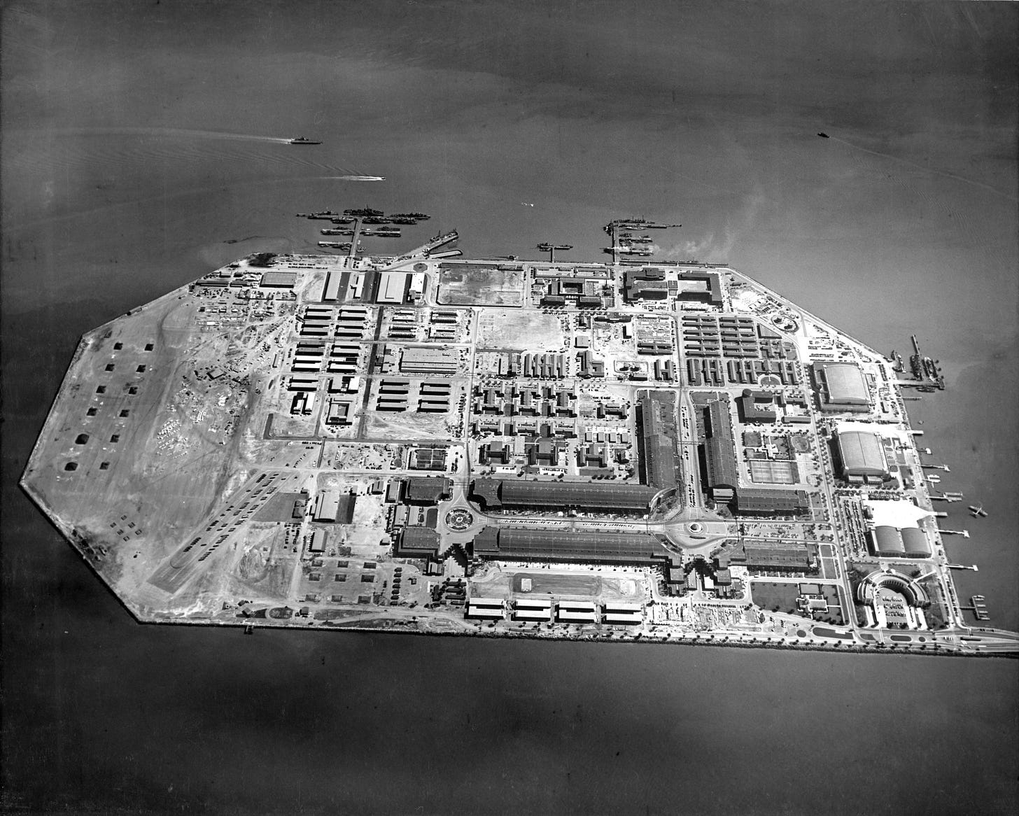
Then, in 1936, the Army Corps of Engineers began its most ambitious project of land creation: Treasure Island. A 400-acre artificial island built on the shoals north of Yerba Buena Island, it was dredged from bay mud at a cost of about $4.5 million at the time, completed in less than two years, and opened in time to host the 1939 Golden Gate International Exposition. When the fair ended, the Navy seized the island and processed 12,000 men a day through it for Pacific assignments.
None of this was controversial. Land reclamation was how the Bay Area grew, accommodating a population that settled in to work in the region’s shipyards and military installations. By the late 1950s, the Army Corps of Engineers estimated that 243 square miles of reclaimable land around the Bay had already been filled. Far from debating whether or not such policies were desirable, city, state, and national officials were consumed with the question of how ambitious and far-reaching land reclamation efforts should be. The idea of regularized terrestrial growth at the time was infectious, inspiring more than just engineers and municipal planners. One of the most ambitious proposals, one that received national attention and federal support, came from a theatrical producer and schoolteacher named John Reber.
Reber had arrived in the Bay in 1907 when he was 20 years old, the year after the earthquake, and spent the next two decades managing musical productions while sketching plans to reshape the entire shoreline. His proposal, first drawn in 1929 and refined over a quarter century, was the San Francisco Bay Project: two earth-and-rock dams, one spanning from Marin County to Richmond and another from San Francisco to Oakland. The dams would convert the Bay into two freshwater lakes storing 2.4 million acre-feet of water annually. Between them, 20,000 acres of filled land would carry a freshwater ship channel, airports, naval installations, and locks comparable in scale to those of the Panama Canal. Rail and highway corridors would run along the tops of the dams conducting wide lanes of automobile traffic.
But for all of Reber’s showmanship and enthusiasm, the project was hampered by his lack of technical expertise. In 1933, a meeting brought him face to face with former President Herbert Hoover, a Stanford-trained geologist who had returned to his alma mater after losing to Roosevelt. Hoover was a mining engineer of international reputation before he was a politician. According to Reber’s later accounts, Hoover called the Reber Plan “the most complete proposal for the Bay.” That endorsement gave the project credibility and Reber knew how to build on it. Soon after, he began to promote his plan full-time — debating with opponents, lobbying policymakers in California and Washington, corresponding with supporters — alone at home on his typewriter.
In 1940, Reber displayed a model of his plan at the World’s Fair on Treasure Island. Two years later, San Francisco’s Board of Supervisors and mayor had formally endorsed the plan. So did the San Francisco Chronicle. California’s farming interests backed it, because the freshwater lakes promised relief from saltwater intrusion into agricultural land. The Navy was interested — Reber, with a showman’s instinct for his audience, had incorporated military installations into successive versions of the plan throughout the war years. When Senator Sheridan Downey of California held hearings for the Senate Subcommittee on Public Works in San Francisco in 1949, advocates outnumbered critics five to one.
The opposition that did emerge was parochial, not principled. The Oakland City Council and the Alameda County Board of Supervisors opposed the plan, fearing that Oakland’s port would be trapped behind a dam, accessible only through locks on filled land off the Berkeley waterfront. But this was a fight over regional advantage, not over the legitimacy of the enterprise. Nobody argued that 20,000 acres of new land were the wrong kind of ambition.
In 1950, Congress funded a full Army Corps feasibility study through the Rivers and Harbors Act. The Corps built a hydraulic model of the entire Bay system in a warehouse in Sausalito — 1.5 acres, reproducing tidal flows from the Pacific to Sacramento at a 1:1,000 horizontal scale and 1:100 vertical. It was among the largest physical models ever constructed. Through testing in the 1950s, it demonstrated that Reber’s barriers would cause catastrophic tidal disruption, salinity collapse, and flooding throughout the southern Bay. By the early 1960s, the plan was dead. The hydraulic model still sits in that Sausalito warehouse, open to visitors as an educational exhibit. It has not been used for research since 2000.
What followed the failure of the Reber plan was not an improved and more sophisticated endeavor to expand San Francisco. It was, in effect, the end of any further land reclamation efforts in the Bay Area. Public pressure in response to land reclamation efforts caused the California legislature to pass the McAteer-Petris Act, creating the Bay Conservation and Development Commission (BCDC) with permit authority over all filling of San Francisco Bay. The BCDC became permanent in 1969. Under its jurisdiction, any placement of fill requires consistency with its Bay Plan document, which prohibits any further land reclamation except for certain transport and public use cases.
Reber’s plan was a flawed work of ambitious engineering. His cost estimates were fantasy and his hydrology was certainly wrong. He was an actor, not an engineer, and the project needed one in order to be rightly designed and implemented. But a new generation of municipal planners took the wrong lesson from his failure — deciding that ambition of that scale, and land reclamation of any scale, should not be allowed any longer.
More so now than ever, San Francisco is a city with too many people competing for too little land in a regulatory environment that heavily restricts new construction, whether transportation, infrastructure, or housing. Even bolder proposals of the modern day — like turning the Presidio into a dense ‘Freedom City’ —suffer from the lack of imagination encouraged by the stifling attitudes towards hardware and terraforming.
Growing San Francisco is entirely technologically feasible. The question is of political will. The fact that an endeavor to create new land in San Francisco would be highly profitable should be an incentive to both local officials and developers.
San Francisco’s 2025 property assessment puts a total land value, stripped of buildings and improvements, at $172 billion across roughly 30,000 acres. That lands at roughly $5.7 million per acre. At this valuation, every square mile of reclaimed land in the city would be worth about 3.6 billion dollars of land value alone. Since the assessor data also includes valuations of the improvements on top of San Francisco’s land, you can factor in improvements comparable to the city average and that figure rises to $11.3 million per acre — on land value alone, before buildings go up. For comparison, Singaporean land reclamation efforts in the 2010s cost between $860,000 to $2.7 million per acre. Building new land in San Francisco would cost a fraction of what that land would be worth once built. Rolling back the BCDC is unlikely to begin with the San Francisco city government: the same authorities who have spent decades tightening their grip on permitting are not likely to loosen it voluntarily. But that’s not to say that it couldn’t happen in San Francisco. Already, housing is being built on Treasure Island, one of the few cases of recent housing construction in the city. But when the city’s own government acknowledges a housing shortage, it should be willing to do much more.

Johan Hendrik van Mastenbroek, “The Day Before the Closing of the Zuiderzee,” May 1932. A sketch of the Afsluitdijk, the dam that closed the Zuiderzee off from the open sea, in its final days of construction.
American cities cannot reject the methods and ambitions that were prerequisites to their construction. A city that owes its existence to a willingness to create new land has only a political reason to halt such enlargement. An intergenerational compact is violated when one generation puts away the tools for building, maintaining, and growing that the next generation will need. Americans sense this, even where they can’t name it — in the anxiety about affordability, the eroding faith that taxes are being well spent, the feeling that the country is consuming itself rather than building towards something material. The unwillingness to do ambitious land reclamation projects is a symptom of those problems.
A country confident in itself would find land reclamation an easy and profitable win. Filling in San Francisco’s shallow shoals would be the least of the projects of civilizational transformation that we could pursue once more. And San Francisco is only the beginning. Such ambition embraces categorical change: if we can refill the Great Salt Lake, restoring water to arid land, there’s no reason that we can’t create new frontiers of land where there once was water. Imagine an America whose territory grows yearly — not through conquest, but by the power of our engineering talent and our innate desire to grow and expand.
Civilization
•
Build Your Own Frontier
The Dutch did it. Singapore did it. China’s doing it. So did we, 100 years ago.
Get the Mag in Print.
Arena publishes four stunning print editions per year, full of stories just like this one on American technology, capital, and industry.
If you could physically reshape the world — raising land from the sea, redirecting rivers, connecting oceans — would you? The answer for most people throughout much of human history would have been yes. Our ancestors’ ambition to change the world outpaced their technological capabilities, but only for so long.
Ferdinand de Lesseps arrived in Egypt in 1854 to realize a dream millennia in the making. By 1869, he had accomplished through human ingenuity what had nearly been a natural accident: connecting the Mediterranean Sea and the Red Sea via the Suez Canal. Following this success, de Lesseps went to South America to lead a feat of engineering even more ambitious, connecting the Atlantic and Pacific through a canal in Panama, cutting the Americas in half. And though de Lesseps was unsuccessful in his time, the attempt set a model that inspired future engineers. The Panama Canal project was subsequently taken up and completed by the United States in 1914. Such undertakings of national advancement were celebrated without apology. God gave man wisdom and free will; it was expected that man would ambitiously use those capabilities to reshape the earth according to humanity’s own needs while using that same wisdom to prudently steward the natural world.
6,000 years ago, humans began reshaping the land they inhabit through surface irrigation. The Dutch made it a national project. Using rudimentary walls to keep out water from the North Sea, the Dutch undertook a multi-century project of claiming new land — called polders — beginning in the 13th century. This process continued for hundreds of years, taking on a new scale and level of sophistication after the Second World War. By 1996, the Dutch Delta Works had reclaimed 620 square miles of polders and created many more miles of transitional wetlands. Today, about 26 percent of the country’s land sits below sea level; this same area contains 60 percent of the nation’s population. Land reclamation enabled territorial growth without conquest and created the Netherlands as we know it today.
More recently, the South Korean government undertook the world’s largest single land reclamation project. Completed in 2006, the Saemangeum Seawall on the southwest coast of the Korean peninsula enclosed 150 square miles for about 3.2 billion dollars. Where the Delta Works largely reclaimed low-lying flooded land, the Saemangeum Seawall goes deeper, down to the seabed averaging 36 meters deep. Advances in reclamation technology enabled South Korean builders to raise more land from further depths.
Or take Singapore. The government wants the country’s landmass to grow from 244 square miles to about 300 by 2030. Singapore is more than halfway there, creating new land for airports, housing, and military infrastructure. Most of the reclaimed land previously sat within 20 meters of the surface. Deeper reclamation, down to 40 and 50 meters, would be an engineering and financial challenge. But for a country like Singapore where small parcels of land lease for millions of dollars, every acre matters.
The most high-profile and potentially concerning example of land reclamation from the American perspective is China’s decade-long effort to build islands in the South China Sea. In the early to mid 2010s, China built more than 3,000 acres of artificial islands across various reefs and shallows in order to assert territorial claims over the waterway. More recently, China has begun dredging work on a disputed shoal, likely to make it fit for docking large naval vessels.
The potential of land-building is enormous, and right now, seemingly constrained more by political will than any international law. Given an acknowledged right for a state to exercise full sovereignty in constructing an artificial island within its Exclusive Economic Zone as per Part V of the United Nations Convention on the Law of the Sea, there is no limit on the size of the island within the 200 nautical mile zone from a nation’s coast. Ambitious modern states are raising islands from the sea and reclaiming acreage from their shorelines to accommodate the growing needs of thriving cities. But not America.
That hasn’t always been the case. American heritage is one of exploring and settling new land. And when there’s no more land to settle, we have a history of building it. There is no better example than San Francisco, both the literal and metaphorical end of the Western frontier. So, when the builders of San Francisco needed new land, they created it.
Before the Gold Rush, Yerba Buena Cove extended inland to what is now Montgomery Street — the Transamerica Pyramid stands on ground that was, in the 1840s, a shallow tidal inlet. When a rush of forty-niners arrived, some five hundred ships clogged the harbor, many of them abandoned by crews who had already left for the gold fields. Enterprising San Franciscans sank them deliberately, claimed the land beneath, and filled the gaps with sand, rubble, and earth. Many of those same ships remain buried under the city’s streets today. By the early 1870s, a seawall enclosed the former cove along what is now the Embarcadero. The city had, within a single generation, manufactured an entire commercial district of 10 acres in what became the densest part of the city.
After the 1906 earthquake, the city used the rubble to fill a marshy cove on the northern waterfront, creating the Marina district in time to host the 1915 Panama-Pacific International Exposition. When the fair closed, developers bought the reclaimed land and built the residential neighborhood that stands there now. On the other side of the city, Mission Bay, once an actual bay, was filled over decades, first with hydraulic mining debris washing down from the Sierra foothills, then with rubble from the earthquake, until by 1910 it had been reduced to a narrow channel. South of Market, at Islais Creek, landowners formed California’s first non-agricultural reclamation district in the 1920s to fill 280 acres of tidal mudflats, quarrying nearly half a million tons of rock from Potrero Hill and Bernal Heights for the seawall alone. At Hunters Point, the Navy filled roughly a square mile of underwater property between 1940 and 1944 to build a wartime shipyard.
Then, in 1936, the Army Corps of Engineers began its most ambitious project of land creation: Treasure Island. A 400-acre artificial island built on the shoals north of Yerba Buena Island, it was dredged from bay mud at a cost of about $4.5 million at the time, completed in less than two years, and opened in time to host the 1939 Golden Gate International Exposition. When the fair ended, the Navy seized the island and processed 12,000 men a day through it for Pacific assignments.
None of this was controversial. Land reclamation was how the Bay Area grew, accommodating a population that settled in to work in the region’s shipyards and military installations. By the late 1950s, the Army Corps of Engineers estimated that 243 square miles of reclaimable land around the Bay had already been filled. Far from debating whether or not such policies were desirable, city, state, and national officials were consumed with the question of how ambitious and far-reaching land reclamation efforts should be. The idea of regularized terrestrial growth at the time was infectious, inspiring more than just engineers and municipal planners. One of the most ambitious proposals, one that received national attention and federal support, came from a theatrical producer and schoolteacher named John Reber.
Reber had arrived in the Bay in 1907 when he was 20 years old, the year after the earthquake, and spent the next two decades managing musical productions while sketching plans to reshape the entire shoreline. His proposal, first drawn in 1929 and refined over a quarter century, was the San Francisco Bay Project: two earth-and-rock dams, one spanning from Marin County to Richmond and another from San Francisco to Oakland. The dams would convert the Bay into two freshwater lakes storing 2.4 million acre-feet of water annually. Between them, 20,000 acres of filled land would carry a freshwater ship channel, airports, naval installations, and locks comparable in scale to those of the Panama Canal. Rail and highway corridors would run along the tops of the dams conducting wide lanes of automobile traffic.
But for all of Reber’s showmanship and enthusiasm, the project was hampered by his lack of technical expertise. In 1933, a meeting brought him face to face with former President Herbert Hoover, a Stanford-trained geologist who had returned to his alma mater after losing to Roosevelt. Hoover was a mining engineer of international reputation before he was a politician. According to Reber’s later accounts, Hoover called the Reber Plan “the most complete proposal for the Bay.” That endorsement gave the project credibility and Reber knew how to build on it. Soon after, he began to promote his plan full-time — debating with opponents, lobbying policymakers in California and Washington, corresponding with supporters — alone at home on his typewriter.
In 1940, Reber displayed a model of his plan at the World’s Fair on Treasure Island. Two years later, San Francisco’s Board of Supervisors and mayor had formally endorsed the plan. So did the San Francisco Chronicle. California’s farming interests backed it, because the freshwater lakes promised relief from saltwater intrusion into agricultural land. The Navy was interested — Reber, with a showman’s instinct for his audience, had incorporated military installations into successive versions of the plan throughout the war years. When Senator Sheridan Downey of California held hearings for the Senate Subcommittee on Public Works in San Francisco in 1949, advocates outnumbered critics five to one.
The opposition that did emerge was parochial, not principled. The Oakland City Council and the Alameda County Board of Supervisors opposed the plan, fearing that Oakland’s port would be trapped behind a dam, accessible only through locks on filled land off the Berkeley waterfront. But this was a fight over regional advantage, not over the legitimacy of the enterprise. Nobody argued that 20,000 acres of new land were the wrong kind of ambition.
In 1950, Congress funded a full Army Corps feasibility study through the Rivers and Harbors Act. The Corps built a hydraulic model of the entire Bay system in a warehouse in Sausalito — 1.5 acres, reproducing tidal flows from the Pacific to Sacramento at a 1:1,000 horizontal scale and 1:100 vertical. It was among the largest physical models ever constructed. Through testing in the 1950s, it demonstrated that Reber’s barriers would cause catastrophic tidal disruption, salinity collapse, and flooding throughout the southern Bay. By the early 1960s, the plan was dead. The hydraulic model still sits in that Sausalito warehouse, open to visitors as an educational exhibit. It has not been used for research since 2000.
What followed the failure of the Reber plan was not an improved and more sophisticated endeavor to expand San Francisco. It was, in effect, the end of any further land reclamation efforts in the Bay Area. Public pressure in response to land reclamation efforts caused the California legislature to pass the McAteer-Petris Act, creating the Bay Conservation and Development Commission (BCDC) with permit authority over all filling of San Francisco Bay. The BCDC became permanent in 1969. Under its jurisdiction, any placement of fill requires consistency with its Bay Plan document, which prohibits any further land reclamation except for certain transport and public use cases.
Reber’s plan was a flawed work of ambitious engineering. His cost estimates were fantasy and his hydrology was certainly wrong. He was an actor, not an engineer, and the project needed one in order to be rightly designed and implemented. But a new generation of municipal planners took the wrong lesson from his failure — deciding that ambition of that scale, and land reclamation of any scale, should not be allowed any longer.
More so now than ever, San Francisco is a city with too many people competing for too little land in a regulatory environment that heavily restricts new construction, whether transportation, infrastructure, or housing. Even bolder proposals of the modern day — like turning the Presidio into a dense ‘Freedom City’ —suffer from the lack of imagination encouraged by the stifling attitudes towards hardware and terraforming.
Growing San Francisco is entirely technologically feasible. The question is of political will. The fact that an endeavor to create new land in San Francisco would be highly profitable should be an incentive to both local officials and developers.
San Francisco’s 2025 property assessment puts a total land value, stripped of buildings and improvements, at $172 billion across roughly 30,000 acres. That lands at roughly $5.7 million per acre. At this valuation, every square mile of reclaimed land in the city would be worth about 3.6 billion dollars of land value alone. Since the assessor data also includes valuations of the improvements on top of San Francisco’s land, you can factor in improvements comparable to the city average and that figure rises to $11.3 million per acre — on land value alone, before buildings go up. For comparison, Singaporean land reclamation efforts in the 2010s cost between $860,000 to $2.7 million per acre. Building new land in San Francisco would cost a fraction of what that land would be worth once built. Rolling back the BCDC is unlikely to begin with the San Francisco city government: the same authorities who have spent decades tightening their grip on permitting are not likely to loosen it voluntarily. But that’s not to say that it couldn’t happen in San Francisco. Already, housing is being built on Treasure Island, one of the few cases of recent housing construction in the city. But when the city’s own government acknowledges a housing shortage, it should be willing to do much more.
Johan Hendrik van Mastenbroek, “The Day Before the Closing of the Zuiderzee,” May 1932. A sketch of the Afsluitdijk, the dam that closed the Zuiderzee off from the open sea, in its final days of construction.
American cities cannot reject the methods and ambitions that were prerequisites to their construction. A city that owes its existence to a willingness to create new land has only a political reason to halt such enlargement. An intergenerational compact is violated when one generation puts away the tools for building, maintaining, and growing that the next generation will need. Americans sense this, even where they can’t name it — in the anxiety about affordability, the eroding faith that taxes are being well spent, the feeling that the country is consuming itself rather than building towards something material. The unwillingness to do ambitious land reclamation projects is a symptom of those problems.
A country confident in itself would find land reclamation an easy and profitable win. Filling in San Francisco’s shallow shoals would be the least of the projects of civilizational transformation that we could pursue once more. And San Francisco is only the beginning. Such ambition embraces categorical change: if we can refill the Great Salt Lake, restoring water to arid land, there’s no reason that we can’t create new frontiers of land where there once was water. Imagine an America whose territory grows yearly — not through conquest, but by the power of our engineering talent and our innate desire to grow and expand.
About the Author
Farrell Gregory is a researcher and non-resident fellow at the Foundation for American Innovation. He is on X @efarrellgregory